Page 1 of 2
Map Project: Great Northern Wilderness (100% DONE)
Posted: Sun Aug 07, 2016 11:01 pm
by Hotrod
Fellow Fantasy Fans,
Glory to the Wolfen Empire! Glistam has commissioned me to give my full mapping treatment to
The Great Northern Wilderness, and has given his blessing to share my progress and products with the community. As always, my goal is to create an image that is both functional and nice to look at, with as much canon information as I can squeeze in.
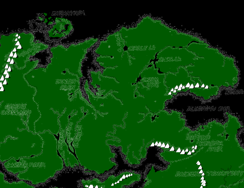
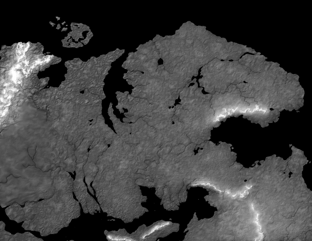
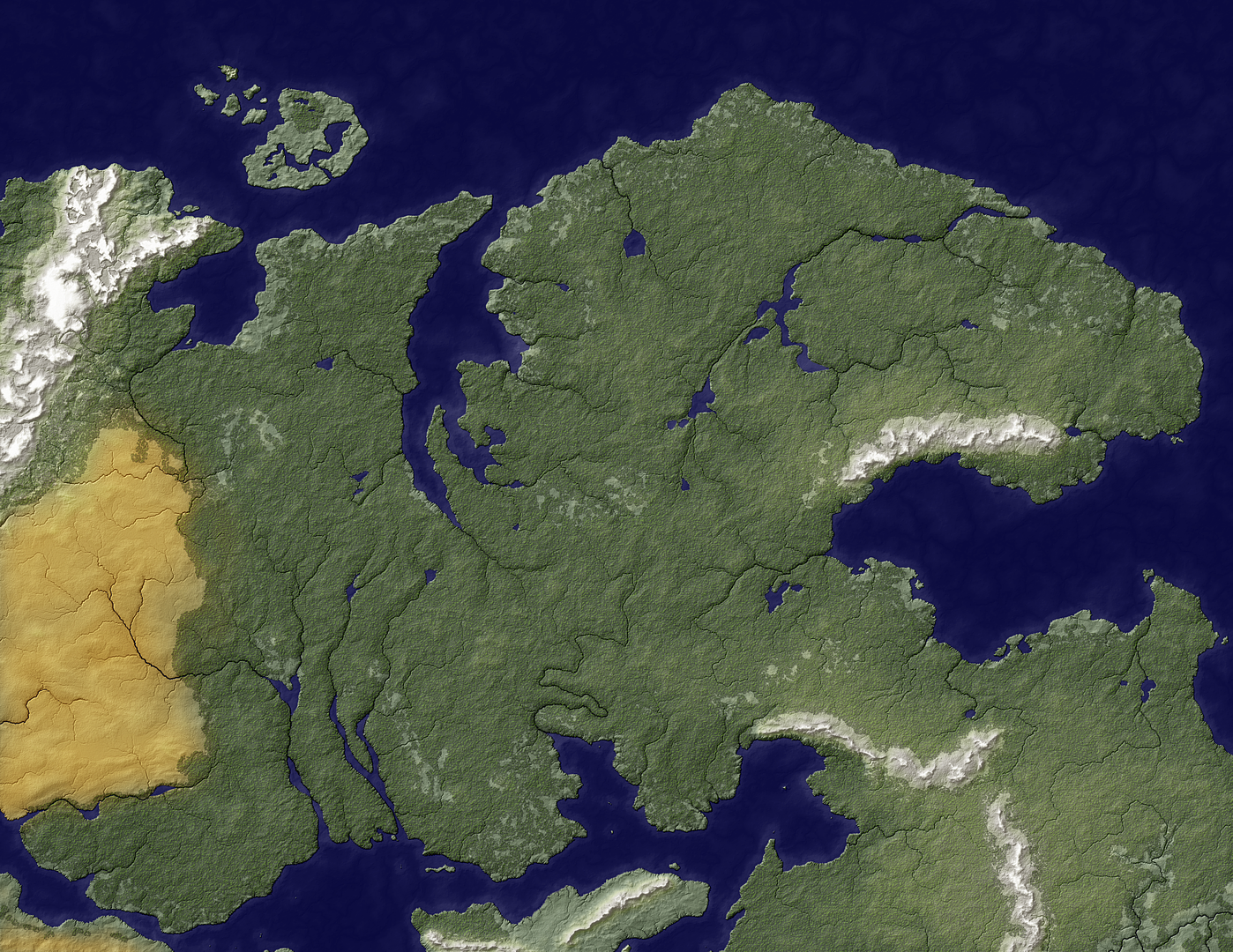
Here is my intended scope of the project with the canon geography, exported from my global Palladium Fantasy Vector Map.
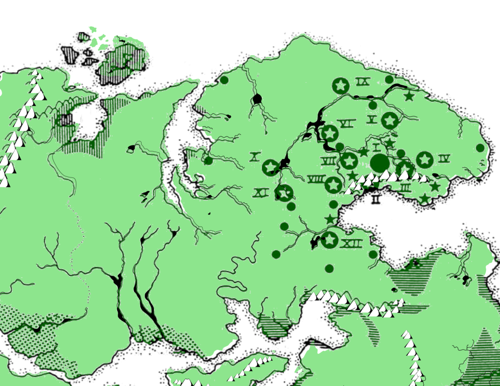
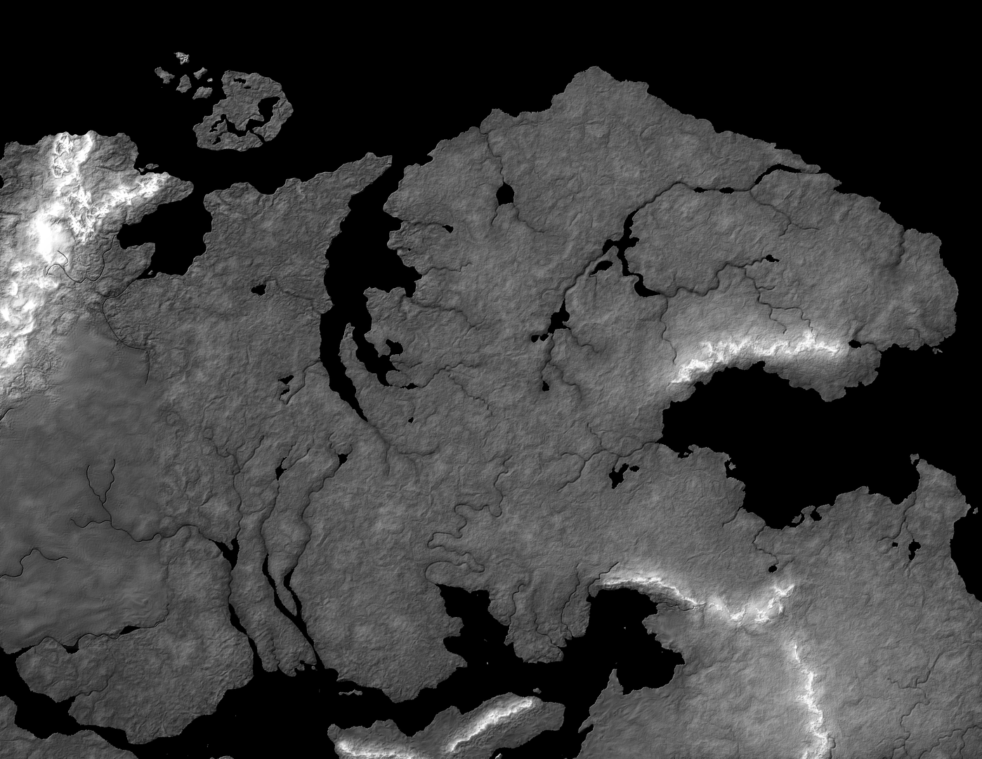
Here's the same scope with some political geography focused on the Wolfen Empire. This will be a full-page treatment that can be printed on an 8.5x11 sheet.
One problem I see right off the bat: the Great Northern Wilderness is huge. Most of the Wolfen Empire's settlements aren't very far from the Algorian Sea. Because this map includes the entire wilderness, it also includes Bizantium and its colonies, most of Ophid's Grasslands, half of Lopan, a fair chunk of the Eastern Territories, and even a bit of the Western Empire and the Land of the Damned. Since most of the Wolfen Empire's 13 trading posts, 7 major cities, and 12 tribal centers are clustered around its capital city, this could pose problems for placing icons and labels. If I try to place and label all the Shadow Colonies and Kiridin lands (which are part of the Great Northern wilderness), this problem could become even more pronounced. I guess I'll deal with that issue when I come to it. I may opt to place un-labeled icons in these areas, as well as the lands outside the Great Northern Wilderness.
One nice thing about the Great Northern Wilderness is that there are only two canon maps that focus on the region, they're both in the same book, and I've already mapped out most of the peripheral lands. Between my maps of Bizantium, the Land of the Damned, and another ongoing project to the south, I should be able to blend in the physical geography of some other areas and focus my efforts on the Wolfen Empire (and the Disputed Lands).
As always, I'd appreciate your help. Am I missing any important sources? Is there any stuff you'd really like to see on this map that I haven't mentioned?
Re: Map Project: The Great Northern Wilderness (Scoping the
Posted: Mon Aug 08, 2016 11:17 am
by Glistam
Whoo-hoo! Looking forward to this!
Re: Map Project: The Great Northern Wilderness (Scoping the
Posted: Mon Aug 08, 2016 11:25 am
by Glistam
One thing I like about the existing maps (and I may be in the minority), is how weird some of the geography is. I mean, what's with that river that looks like a witch's profile? I think it fits for a fantasy world well but I imagine the topography that creates a river such as that is a bit difficult to image and model.
I think I saw a map somewhere that connects at least one of the rivers from the southern coast with the Dragon Fingers lake, and makes sense considering that Lopan has "strengthened ties" with Bizantium and is even working with a Bizantium consultant on a joing shipbuilding project (Eastern Territories, page 109). If I can find that picture I'll post the book and page number.
EDIT: Pages 20 and 139 of the Northern Hinterlands have that world map which seems to show the connection. I'm not sure which of the three rivers this would replace (if any), but I personally really like the one river that "ends" (or "begins?") with what looks like a crescent moon and wouldn't want to see that one changed.
Re: Map Project: The Great Northern Wilderness (Scoping the
Posted: Mon Aug 08, 2016 2:51 pm
by Hotrod
Yeah, there are some weird bits to Palladium Fantasy's cartography. My personal favorite is the Old Kingdom River, which flows towards and through two mountain ranges and turns away from a nearby coast to do so. I'm trying to find this witch profile river without success, but I guess this is kind of like a Rorschach test.
Regarding the river link between Dragon Claw and the Inland Sea, you seem to be interpreting an uneven line as a river. That's a perfectly legitimate interpretation, but in the context of the Northern Hinterlands maps, I think that jagged line is meant to differentiate the Northern Hinterlands region from the Great Northern Wilderness. It's a way of marking out the regions described in the book. I don't think it's meant to imply a direct water link between two bodies of water like the Great Canal that cuts across the Eastern Territory. Canals generally require large-scale efforts, and the region that line cuts through is among the most sparsely populated and least-developed outside of the Great Ice Shelf. Such a water link would be incredibly important and would likely be mentioned in the published canon. My inclination would be to portray the waterways as shown in Wolfen Empire p18. There's plenty of river to get most of the way to Dragon Claw, just not all the way.
On a related note, the maps in Northern Hinterlands (and, by extension, the Land of the Damned books, which all fit together nicely) don't play very well with the rest of the established Palladium Fantasy canon. In the original world description and the one provided in Palladium Fantasy 2E page 282, the Great Northern Wilderness includes the entire mainland north of the Inland Sea other than the Land of the Damned and Ophid's Grasslands. According to this description, the Northern Hinterlands do not exist. In the Northern Hinterlands book, the Northern Hinterlands include the Shadow Colonies, Ophid's Grasslands, Kiridin, and a bunch of territory between Ophid's Grasslands and Dragon Claw.
Effectively, the published canon constitutes a Venn diagram of two partially-overlapping shapes. Ophid's Grasslands is definitely not in the Great Northern Wilderness, and the Wolfen Empire's settlements are definitely not in the Northern Hinterlands. However, there is a huge overlap region that includes the Shadow Colonies, Kiridin, and all the land between Ophid's Grasslands and Dragon Claw. These could be correctly interpreted as being in either or both regions. Of course, this could simply be a matter of different peoples in Palladium labeling the same regions differently, but capturing that kind of multiple-interpretation nuance in a single map isn't practical. I want to make the best canon-faithful map that I can, so I need to pick an interpretation and run with it. This isn't terribly important at this stage of making the map, as the Great Northern Wilderness extends all the way to Ophid's Grasslands in the south by any interpretation, but it will be important later when it's time to do borders and labels. Maybe I can get an official answer by then.
In the meantime, I've got some detail work on the coasts to do.
Re: Map Project: The Great Northern Wilderness (Scoping the
Posted: Tue Aug 09, 2016 10:35 am
by Glistam
A consideration could be to not include a dividing line between the Northern Wilderness/Wolfen Empire and the Northern Hinterlands, and instead just place a label in the areas. That leaves the border of those areas to each other subjective, which certainly seems appropriate.
Re: Map Project: The Great Northern Wilderness (Scoping the
Posted: Tue Aug 09, 2016 10:43 am
by Braden Campbell
Hotrod wrote:Yeah, there are some weird bits to Palladium Fantasy's cartography. My personal favorite is the Old Kingdom River, which flows towards and through two mountain ranges and turns away from a nearby coast to do so. I'm trying to find this witch profile river without success, but I guess this is kind of like a Rorschach test...
I made peace with it by figuring that the source of the river is the Old Kingdom Mountains - from there, one side flows eastward to eventually empty into the Inland Sea... the other half flows westerly, over the Great Falls and peters out somewhere in the dry Old Kingdom interior.
Re: Map Project: The Great Northern Wilderness (Scoping the
Posted: Tue Aug 09, 2016 3:06 pm
by Hotrod
Glistam wrote:A consideration could be to not include a dividing line between the Northern Wilderness/Wolfen Empire and the Northern Hinterlands, and instead just place a label in the areas. That leaves the border of those areas to each other subjective, which certainly seems appropriate.
That's a good idea. I'll see if I can make that work.
Re: Map Project: The Great Northern Wilderness (Scoping the
Posted: Mon Aug 15, 2016 1:50 pm
by Hotrod
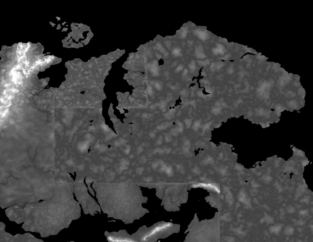
Update: Here's the latest draft. Admittedly, it's a mess, but there's hope.
I've worked out the coastlines for the Great Northern Wilderness. I've also worked in land sculpts from three other maps (Land of the Damned, Bizantium, and another map I'm making of the Inland Sea). This should make this map's coast and terrain closely match that of my other maps. Now I just need to blend in these other land sculpts and sculpt the rest. I've never worked in three separate maps this way before. This should be interesting.
Re: Map Project: The Great Northern Wilderness (Land Sculpti
Posted: Mon Aug 15, 2016 5:11 pm
by J_cobbers
Impressive work as usual! Once you've gotten your geography laid out and blended in, don't forget about the Bruu-ga Belimar Mountains and the village of Wirjin from Further Adventures / Wolfen Empire. There are also the various Member States and Imperial States. I don't know if there are any good sources for their locations or boarders however. I just have Wolfen Empire and the original Adventures books to consult.
Re: Map Project: The Great Northern Wilderness (Land Sculpti
Posted: Tue Aug 16, 2016 10:17 am
by Hotrod
J_cobbers wrote:Impressive work as usual! Once you've gotten your geography laid out and blended in, don't forget about the Bruu-ga Belimar Mountains and the village of Wirjin from Further Adventures / Wolfen Empire. There are also the various Member States and Imperial States. I don't know if there are any good sources for their locations or boarders however. I just have Wolfen Empire and the original Adventures books to consult.
Thank you for the kind words! No worries on the mountains; I have them all plotted out on my world vector map; I just have to put them in. As for the Wolfen Empire, the boundaries between tribes and member states seem to be pretty nebulous, especially in the remote, western areas. If I do regional boundaries within the empire, they'll be educated guesses. I'll cross that bridge when I come to it.
Re: Map Project: The Great Northern Wilderness (Land Sculpti
Posted: Wed Aug 24, 2016 5:25 pm
by RavenStarver
I love the Northern Wilderness as a location and this looks fantastic and I can't wait to see the outcome!
Re: Map Project: The Great Northern Wilderness (Land Sculpti
Posted: Fri Sep 02, 2016 8:24 am
by Hotrod
RavenStarver wrote:I love the Northern Wilderness as a location and this looks fantastic and I can't wait to see the outcome!
I appreciate (and share) the enthusiasm!
Quick status update: the mountains are all placed. Now I'm doing one of the big time-consuming phases of creating the map: sculpting the land. I have to smooth the terrain out and define the rivers and river valleys. This involves a lot of airbrushing. No progress shot today, but I'm hoping to have a presentable land sculpt within a week or so.
Re: Map Project: The Great Northern Wilderness (Land Sculpti
Posted: Fri Sep 02, 2016 9:40 am
by Glistam
Hotrod wrote:RavenStarver wrote:I love the Northern Wilderness as a location and this looks fantastic and I can't wait to see the outcome!
I appreciate (and share) the enthusiasm!
Quick status update: the mountains are all placed. Now I'm doing one of the big time-consuming phases of creating the map: sculpting the land. I have to smooth the terrain out and define the rivers and river valleys. This involves a lot of airbrushing. No progress shot today, but I'm hoping to have a presentable land sculpt within a week or so.
Awesome!
Re: Map Project: The Great Northern Wilderness (Land Sculpti
Posted: Sat Sep 03, 2016 3:49 am
by kiralon
This is going to be kewl
Re: Map Project: The Great Northern Wilderness (Scoping the
Posted: Sat Sep 03, 2016 4:13 pm
by Soldier of Od
Braden Campbell wrote:Hotrod wrote:Yeah, there are some weird bits to Palladium Fantasy's cartography. My personal favorite is the Old Kingdom River, which flows towards and through two mountain ranges and turns away from a nearby coast to do so. I'm trying to find this witch profile river without success, but I guess this is kind of like a Rorschach test...
I made peace with it by figuring that the source of the river is the Old Kingdom Mountains - from there, one side flows eastward to eventually empty into the Inland Sea... the other half flows westerly, over the Great Falls and peters out somewhere in the dry Old Kingdom interior.
I explained this by saying that the whole of that area of the southern Old Kingdom is a high plateau, in part due to the tectonic/volcanic activity that also created Mounts Nimro and Nimrod. The first part of the Old Kingdom River flows from the upper part of the plateau near the volcanoes and is kind of 'trapped' and funnelled by the Old Kingdom Mountains. The coastline of Baalgor and 'the Scarlet Coast' is all high cliffs, which helps with the higher elevation explanation. I guess it drops as one travels south, also helping to explain why there are marshes at its base near the South Winds, due to all the water run off, and a fairly large bay (between South Winds and Timiro) fed by a relatively small river. The other (eastern) side of the Old Kingdom Mountains (the Froud Grassland) must be lower, down the Great Falls
this way (but the falls do seem to be the wrong side of the mountains!). The path through the mountains may have been worn by river over time (maybe long ago in the past it used to flow south past the Silver Range Mountains?) or may have been opened up by something magical!
Sorry, I know this is off topic - I just wanted to share!
Re: Map Project: The Great Northern Wilderness (Land Sculpti
Posted: Sat Sep 03, 2016 9:32 pm
by Hotrod
Soldier of Od wrote:Braden Campbell wrote:Hotrod wrote:Yeah, there are some weird bits to Palladium Fantasy's cartography. My personal favorite is the Old Kingdom River, which flows towards and through two mountain ranges and turns away from a nearby coast to do so. I'm trying to find this witch profile river without success, but I guess this is kind of like a Rorschach test...
I made peace with it by figuring that the source of the river is the Old Kingdom Mountains - from there, one side flows eastward to eventually empty into the Inland Sea... the other half flows westerly, over the Great Falls and peters out somewhere in the dry Old Kingdom interior.
I explained this by saying that the whole of that area of the southern Old Kingdom is a high plateau, in part due to the tectonic/volcanic activity that also created Mounts Nimro and Nimrod. The first part of the Old Kingdom River flows from the upper part of the plateau near the volcanoes and is kind of 'trapped' and funnelled by the Old Kingdom Mountains. The coastline of Baalgor and 'the Scarlet Coast' is all high cliffs, which helps with the higher elevation explanation. I guess it drops as one travels south, also helping to explain why there are marshes at its base near the South Winds, due to all the water run off, and a fairly large bay (between South Winds and Timiro) fed by a relatively small river. The other (eastern) side of the Old Kingdom Mountains (the Froud Grassland) must be lower, down the Great Falls
this way (but the falls do seem to be the wrong side of the mountains!). The path through the mountains may have been worn by river over time (maybe long ago in the past it used to flow south past the Silver Range Mountains?) or may have been opened up by something magical!
Sorry, I know this is off topic - I just wanted to share!
Your explanation is perfectly plausible, and thanks for sharing! My head-shake at the Old Kingdom River is mostly due to my work in cartography. Rivers always flow away from mountains, never towards them, and rivers work towards coasts, not away from them. Of course, given all the supernatural stuff in the Palladium Fantasy world, a supernatural river seems quite reasonable. It's just a hassle for me to make. Thankfully, it's not a part of this map.
On an unrelated note, I'm working on heraldry and map symbols, too. There are a lot of sub-factions in the Wolfen Empire. If there's enough space, I'll write them into the map with their heraldry, like I did with the Kiridin lands in my Bizantium map. If not, I'll put in symbols and have a factions legend in an expanded border, like I did with my Regnum map.
Re: Map Project: The Great Northern Wilderness (Land Sculpti
Posted: Sun Sep 04, 2016 11:14 pm
by Hotrod
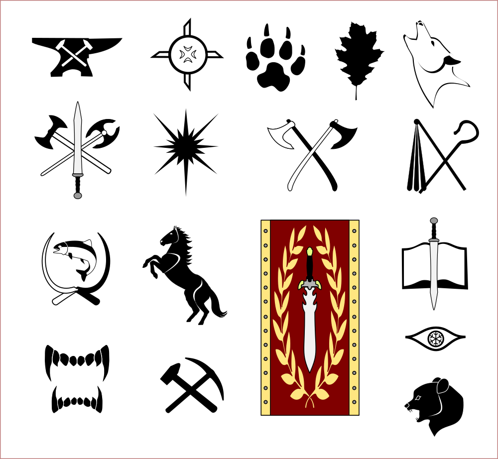
Update: I took a break from land sculpting today and played with icons and heraldry. I've drafted
icons for the Wolfen Empire, its 12 tribes, Havea, the Algor Mountain Collective, and the Diamond Point Horde.Please have a look and let me know what you think.
Notes on these icons:
-Not all of these are originals. The big imperial banner, for instance, is a recreation of the banners on page 10 of Wolfen Empire. The oak leaf is adapted from a trace of a leaf I found from a google image search. The circular rune is the magic power rune from Palladium Fantasy.
-Most of these have at least one element that I'm re-using from other works. Hey, if it ain't broke...
-Some of these are fairly polished, while others need work. The idea with this is to make some symbolic heraldry that someone familiar with the member states of the Wolfen Empire could identify without having a label right there.
-The January Magic Tribe's placeholder icon is a magic rune because I can't think of anything better at the moment. I don't care for what I've done, and I'm open to ideas.
-There are two ice-eyes symbols: the white wolf and the snowflake-iris-eye. I haven't decided which I prefer yet.
-I'm not yet sure how I'll present this heraldry.
Heraldic shield icons are fun, but I don't want to overpower the map with the heraldry.
Back to land-sculpting!
Re: Map Project: The Great Northern Wilderness (Land Sculpti
Posted: Wed Sep 14, 2016 12:22 pm
by Hotrod
You know one of the things I both love and hate about making these maps? I keep finding stuff as I go through the books. Yesterday, I was flipping through Adventures on the High Seas, looking for some information on Y-Oda as I was contemplating including it in the map. I decided against it, as the whole "claimed by the Wolfen Empire" thing is something of an empty symbolic gesture. Anyway, I got distracted by the book (as I often do when researching for these map projects) and I found something that I can't believe I never caught before.
Every major seafaring power in the world has flag heraldry described in the High Seas book, in the ships of the world section. My Bizantium map used anchors as their symbol, and that is not canon! Their national insignia is an otter, and it's presented on a green and white flag. Bad news: I need to revise my Bizantium map again. Good news: the symbol for the Wolfen Empire is a paw print on a white or silver background, and I already have a paw print!
I'll fix the Bizantium map after I finish my Northern Wilderness map, but I'll be using
this otter icon that I drew up this morning as the Bizantium sigil for this map.
(I've also been making progress on the land sculpt; I'll post a progress shot later)
Re: Map Project: The Great Northern Wilderness (Land Sculpti
Posted: Wed Sep 14, 2016 1:25 pm
by Glistam
That still happens to me, even after years of having read and re-read the books. It seems like there's always some little thing you didn't notice previously that's applicable elsewhere.
Re: Map Project: The Great Northern Wilderness (Land Sculpti
Posted: Wed Sep 14, 2016 8:00 pm
by Reagren Wright
Hotrod wrote:You know one of the things I both love and hate about making these maps? I keep finding stuff as I go through the books. Yesterday, I was flipping through Adventures on the High Seas, looking for some information on Y-Oda as I was contemplating including it in the map. I decided against it, as the whole "claimed by the Wolfen Empire" thing is something of an empty symbolic gesture. Anyway, I got distracted by the book (as I often do when researching for these map projects) and I found something that I can't believe I never caught before.
Every major seafaring power in the world has flag heraldry described in the High Seas book, in the ships of the world section. My Bizantium map used anchors as their symbol, and that is not canon! Their national insignia is an otter, and it's presented on a green and white flag. Bad news: I need to revise my Bizantium map again. Good news: the symbol for the Wolfen Empire is a paw print on a white or silver background, and I already have a paw print!
I'll fix the Bizantium map after I finish my Northern Wilderness map, but I'll be using
this otter icon that I drew up this morning as the Bizantium sigil for this map.
(I've also been making progress on the land sculpt; I'll post a progress shot later)
I knew their flag was an otter. In fact I also believe besides mentioning it in the ships section, in one of the little stories it
talks about the otter flag waving in the air. Personally if it wasn't cannon already, I would have changed it to your anchor.
An otter for your flag? Your the kingdom that hunts down sea serpents, travels the Sea of Despair, and your arguably the
most powerful navy in the world and your flying a flag with an otter on it

.
Pirate. "Look captain its a Bizantium Battleship."
Pirate. "How can you tell you swine."
Pirate. I see the otter flag. Aah isn't he cute.
Re: Map Project: The Great Northern Wilderness (Land Sculpti
Posted: Wed Sep 14, 2016 8:43 pm
by Prysus
Reagren Wright wrote:I knew their flag was an otter. In fact I also believe besides mentioning it in the ships section, in one of the little stories it
talks about the otter flag waving in the air. Personally if it wasn't cannon already, I would have changed it to your anchor.
An otter for your flag? Your the kingdom that hunts down sea serpents, travels the Sea of Despair, and your arguably the
most powerful navy in the world and your flying a flag with an otter on it
.
Pirate. "Look captain its a Bizantium Battleship."
Pirate. "How can you tell you swine."
Pirate. I see the otter flag. Aah isn't he quite.
Greetings and Salutations. That's because they were late to the game.
"We hunt sea serpents. So what say you to a hunting beast, a hound!"
"The Western Empire already has a hunting hound for its flag."
"Well okay then, how about a powerful and mighty sea serpent?"
"The South-Winds already has a winged dragon, and they kind of laid claim to serpents in general."
"Fine. Then something strong and majestic. Maybe a Gryphon soaring across --"
"Actually, Timiro already --"
"An otter then! Does anyone have the otter smart guy?!"
"Um ... I don't think so."
"Good! We're the otters. Happy now?!"
"But I don't want to be an otter."

"Of course not! No one wants to be an otter. That's why no one else picked it. But then you wanted to open your big mouth, so too bad. You're an otter now! I'm an otter, you're otter, we're all freaking otters."
And that's why South-Winds will always be more awesome than Bizantium.

Just sayin'. Farewell and safe journeys to all.
Re: Map Project: The Great Northern Wilderness (Land Sculpti
Posted: Wed Sep 14, 2016 9:49 pm
by Hotrod
Yeah, otters don't seem like particularly fierce creatures, but they were a lot of fun to draw today.
I tried to draw the first otter icon as stately as I could. I also drew and added in a second one, a running otter, who has this wavy shape to his body that would go well on a billowing flag.
One observation I made during my time in the army: the more hard-core-sounding a unit's callsign/symbol is, the further they are from anything approaching violence. If someone called "annihilator" calls you on the radio, that's probably the finance unit. If someone called "apple" calls you, you're talking to a special ops guy.
So yeah, otters might not strike fear into your hearts, but when you see ships flying the otter swallow-tailed flag tearing up sea serpents, rescuing you from your shipwrecked galley, or holding its own against a Black Demon Ship, that otter is going to earn a whole new reputation.
Re: Map Project: The Great Northern Wilderness (Land Sculpti
Posted: Thu Sep 15, 2016 1:34 pm
by J_cobbers
Hotrod wrote:Yeah, otters don't seem like particularly fierce creatures, but they were a lot of fun to draw today.
I tried to draw the first otter icon as stately as I could. I also drew and added in a second one, a running otter, who has this wavy shape to his body that would go well on a billowing flag.
One observation I made during my time in the army: the more hard-core-sounding a unit's callsign/symbol is, the further they are from anything approaching violence. If someone called "annihilator" calls you on the radio, that's probably the finance unit. If someone called "apple" calls you, you're talking to a special ops guy.
So yeah, otters might not strike fear into your hearts, but when you see ships flying the otter swallow-tailed flag tearing up sea serpents, rescuing you from your shipwrecked galley, or holding its own against a Black Demon Ship, that otter is going to earn a whole new reputation.
If I was going to pick an animal for my fictional heraldry, it would be the rare dreaded northern ice weasel.
On my own Army history, one of my first units call sign was the Monarchs, a Transportation Unit. It was supposed to be in reference to royalty, because our heraldry had Rex Via, or King of the Road in Latin, but I always thought of the butterfly first whenever someone made a reference to the call sign. Funny enough a later infantry unit I was assigned to was the "Duke" brigade, which to me always seemed like a royalty themed but was actually a reference to John Wayne.
Re: Map Project: The Great Northern Wilderness (Land Sculpti
Posted: Thu Sep 15, 2016 2:58 pm
by Hotrod
The land sculpt is nearing completion.
Here's a preliminary version that doesn't include erosion effects. I still have a few issues to work out:
-The area where I imported my Bizantium and Inland Sea land sculpts have a higher density of big hills than the rest of the map, as they were done at very different scales. I've done some blending to address this around the Inland Sea, and I think I need to do some more around Bizantium and Kiridin.
-The new mountains need work. The peaks are ok, but the shoulders are way too smooth.
-You can still see a bit of a hard edge at the northeast corner of the Inland sea. That should be a quick fix.
If you have the time/interest, please take a good hard look at this and let me know if I'm missing anything else (rivers, lakes, mountains, hills). I'll likely have to do more land sculpting after I run this through the erosion and natural water flow program, so there will be some more revisions.
Re: Map Project: The Great Northern Wilderness (Land Sculpti
Posted: Fri Sep 16, 2016 4:09 pm
by Hotrod
The land sculpt continues. I did an erosion run yesterday, and spent an hour or two adjusting things to make the rivers flow closer to their canon paths.
Here's the second land sculpt pre-erosion. Overall, I solved the issues I mentioned in the last update. One of the Northern Mountains looks a bit flat on the top; I can fix that without much trouble.
With the erosion effects and a simple color gradient applied, here's the land sculpt. I need to go over it in detail to see what I've missed this time, but at a quick glance it looks like the rivers are conforming much better to canon now, with only one major river deviating from its main path. The Great Canal and its assorted rivers aren't behaving, but I wasn't expecting them too; I'll have to draw those in by hand.
Anyway, have a look and feel free to nit-pick.
Re: Map Project: The Great Northern Wilderness (Land Sculpti
Posted: Sun Sep 18, 2016 4:27 pm
by J_cobbers
Hotrod wrote:The land sculpt continues. I did an erosion run yesterday, and spent an hour or two adjusting things to make the rivers flow closer to their canon paths.
Here's the second land sculpt pre-erosion. Overall, I solved the issues I mentioned in the last update. One of the Northern Mountains looks a bit flat on the top; I can fix that without much trouble.
With the erosion effects and a simple color gradient applied, here's the land sculpt. I need to go over it in detail to see what I've missed this time, but at a quick glance it looks like the rivers are conforming much better to canon now, with only one major river deviating from its main path. The Great Canal and its assorted rivers aren't behaving, but I wasn't expecting them too; I'll have to draw those in by hand.
Anyway, have a look and feel free to nit-pick.
I find it very hard to nit pick with the quality and attention to detail you invest in your maps. I love the level of devotion to making details like realistic geography of a fictional setting work. Given the 2-D source material you are starting with, this is a real step up in quality!
Re: Map Project: The Great Northern Wilderness (Land Sculpti
Posted: Mon Sep 19, 2016 12:39 am
by Hotrod
J_cobbers wrote:I find it very hard to nit pick with the quality and attention to detail you invest in your maps. I love the level of devotion to making details like realistic geography of a fictional setting work. Given the 2-D source material you are starting with, this is a real step up in quality!
Thanks for the kind words! My goal is to create a map with improved utility and quality over the pertinent canon maps.
Update: the land sculpt is done! Here is the latest version of the map.Changes from the last version:
+I've fixed and tweaked a lot of rivers
+I've added a new climate zone for Ophid's Grasslands, going for a prairie look.
+Other minor tweaks and adjustments.
Up next will probably either be forests or bathymetry. Lots of work still to do.
Re: Map Project: The Great Northern Wilderness (Water/Woods)
Posted: Mon Sep 19, 2016 12:59 am
by kiralon
I can feel an expedition to the northern wilderness coming on.
Re: Map Project: The Great Northern Wilderness (Water/Woods)
Posted: Mon Sep 19, 2016 10:09 am
by Glistam
That's looking amazing so far!
Re: Map Project: The Great Northern Wilderness (Water/Woods)
Posted: Mon Sep 19, 2016 10:40 pm
by Hotrod
Update: I might do a few tweaks later if I see something that needs adjusting, but
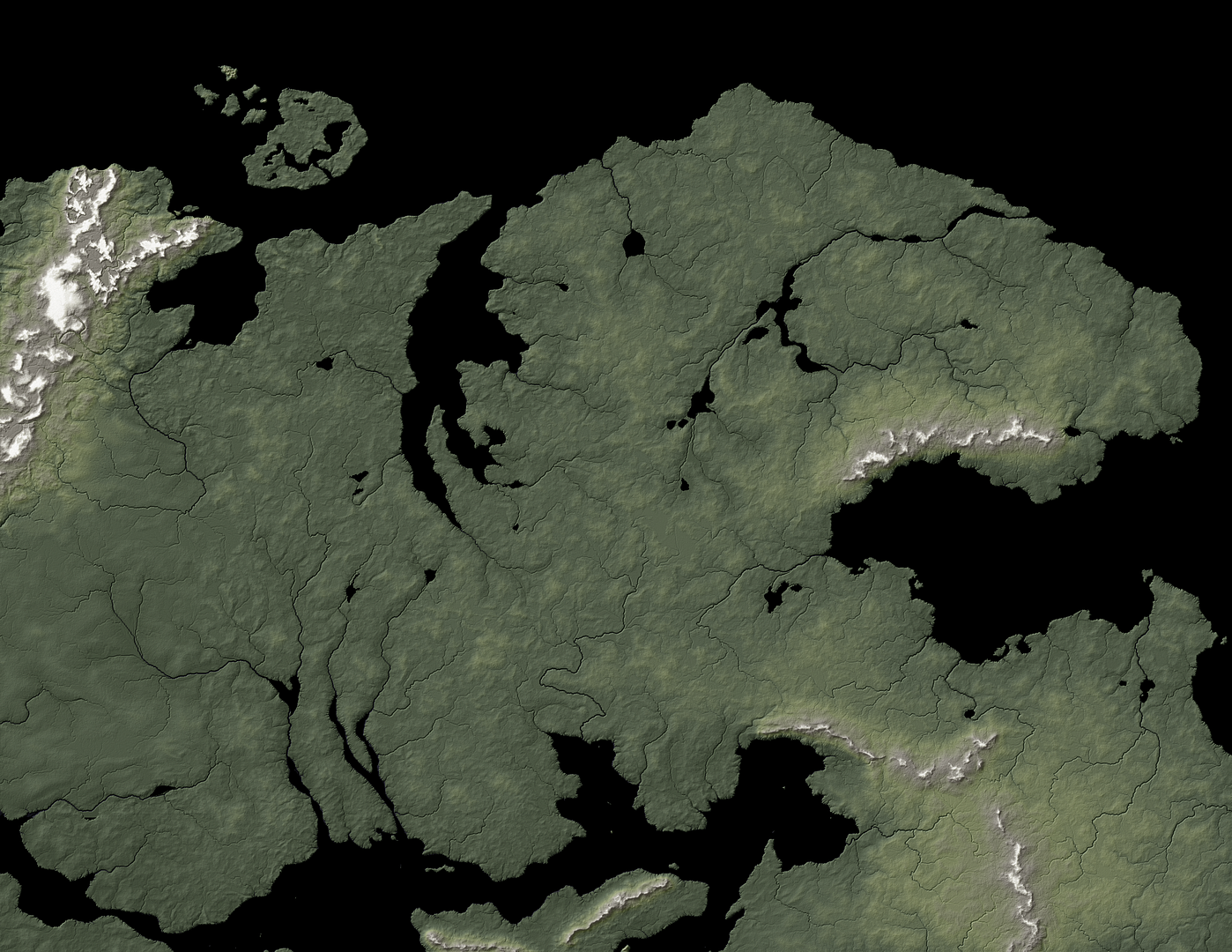
here is the complete bare geography!New features:
+I've added water effects and I came up with a new technique for showing the coastal shallows and deeper regions that I'm liking.
+I added woods. Lots of woods. In fact, I may have overdone them a touch, but this part of the world seems to be very heavily forested. I'll look for regions where I can pare the forest back a bit as I continue researching the political geography.
+I added some prairie coloring to the part of the Western Empire that shows up on the map. This is the Tarlded Plains, a grassland-dominated area.
I'll probably do a natural geography map next, adding labels and a compass rose/scale. I may add in some ley lines too. Then it'll be time for the political geography, with settlement icons, borders, and heraldry.
As always, please feel free to critique. It's very easy for me to miss things as I do this.
Re: Map Project: The Great Northern Wilderness (Water/Woods)
Posted: Mon Sep 19, 2016 11:11 pm
by Hotrod
kiralon wrote:I can feel an expedition to the northern wilderness coming on.
It's neat how ideas can spring to mind as I work on these maps. Last week, while researching this region, an idea came to mind that I just had to write down: a 3-adventure mini-campaign that involves this region and is centered on the history and politics of the Wolfen Empire. I'm hoping I can polish it into something worthy of the Rifter, but that'll have to wait until I finish this map.
Glistam wrote:That's looking amazing so far!
Thank you! I hope you like what I do with this next.
Re: Map Project: The Great Northern Wilderness (Water/Woods)
Posted: Tue Sep 20, 2016 12:32 am
by kiralon
Hotrod wrote:kiralon wrote:I can feel an expedition to the northern wilderness coming on.
It's neat how ideas can spring to mind as I work on these maps. Last week, while researching this region, an idea came to mind that I just had to write down: a 3-adventure mini-campaign that involves this region and is centered on the history and politics of the Wolfen Empire. I'm hoping I can polish it into something worthy of the Rifter, but that'll have to wait until I finish this map.
I have a few ideas as well, but they only work if I can supply an accurate map, and this should cover that nicely.
Re: Map Project: The Great Northern Wilderness (Water/Woods)
Posted: Wed Sep 21, 2016 3:50 am
by zyanitevp
kiralon wrote:I can feel an expedition to the northern wilderness coming on.
No, really? I mean people are paying for maps, cannot be a clue at all....
Sorry, sarcasm break over- we return you now to your regularly scheduled forum discussion....
Re: Map Project: The Great Northern Wilderness (Water/Woods)
Posted: Wed Sep 21, 2016 3:53 am
by zyanitevp
Hotrod wrote:Update: I might do a few tweaks later if I see something that needs adjusting, but
here is the complete bare geography!New features:
+I've added water effects and I came up with a new technique for showing the coastal shallows and deeper regions that I'm liking.
+I added woods. Lots of woods. In fact, I may have overdone them a touch, but this part of the world seems to be very heavily forested. I'll look for regions where I can pare the forest back a bit as I continue researching the political geography.
+I added some prairie coloring to the part of the Western Empire that shows up on the map. This is the Tarlded Plains, a grassland-dominated area.
I'll probably do a natural geography map next, adding labels and a compass rose/scale. I may add in some ley lines too. Then it'll be time for the political geography, with settlement icons, borders, and heraldry.
As always, please feel free to critique. It's very easy for me to miss things as I do this.
The Ophid's Grasslands are fully part of the Empire, but are cut off here....
Other than that, amazed that each effort is an improvement- well done!!
Re: Map Project: The Great Northern Wilderness (Water/Woods)
Posted: Wed Sep 21, 2016 8:30 am
by Hotrod
zyanitevp wrote:The Ophid's Grasslands are fully part of the Empire, but are cut off here....
Other than that, amazed that each effort is an improvement- well done!!
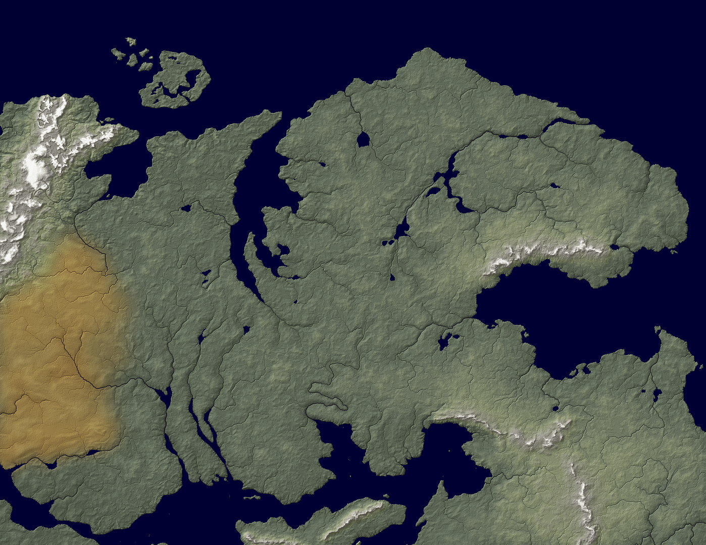
Interesting. Do you have a reference for that? Reading through the "Geography of the Wolfen Empire" section on page 47 of the Wolfen Empire, the de facto western limit of the empire is Dragon Claw and the Taber River. Page 282 of P2E shows the Great Northern Wilderness as stretching as far west as the south banks of the Garter River, and it states that the empire claims the entire Great Northern Wilderness and part of the north Eastern Territory. That passage was what I used to set the scope of the map. If you need a bit more of Ophid's Grassland, you can use my Land of the Damned map, which includes the western part of that region.
Reading through the geography of the wolfen empire section again, I see that I've goofed a bit on my tree placement and concentration, especially along the north coast. I'll clear out some of the forests there and work in some tundra coloring. I'm also spotting some internal canon inconsistencies. The book states that the Algorian Coast has many cities, while north of the Algor Mountains there are few settlements to speak of. However, when I look at where the cities are supposed to be, I see six tribal capitals, four major cities, and the capital city of the entire empire north of the Algor Mountains.
I've placed most of the natural geography labels, and I might not make a full-up natural geography version; there's a lot of empty space and un-named rivers and lakes. We'll see. I've also been testing out an idea for marking some of the political and factional features. The political map is going to need a big legend.
I also just saw two tiny lakes that I missed in my world vector map (and therefore this one as well!). Another item for the to-do list. Sheesh.
Re: Map Project: Great Northern Wilderness (Bare Map DONE!)
Posted: Wed Sep 21, 2016 10:10 am
by Glistam
I'm also spotting some internal canon inconsistencies. The book states that the Algorian Coast has many cities, while north of the Algor Mountains there are few settlements to speak of. However, when I look at where the cities are supposed to be, I see six tribal capitals, four major cities, and the capital city of the entire empire north of the Algor Mountains.
I don't see this as an inconsistency. I interpret that to mean that, with few exceptions, the cities and locations noted north of the Algor Mountains are pretty much it for civilization up there. Meanwhile, all along the coast is civilization and cities, and only the ones of "note" made it onto the map - such as the three "major" cities, two tribal centers (Seahawk and Ironclaw), and two trading centers which are all noted. Also, I looked at the tribe entries again and noticed that both the Seahawk and Ironclaw are mainly farmers, while the tribes north of the Algor Mountains are mostly hunter/gatherers. That may also play a part?
Re: Map Project: Great Northern Wilderness (Bare Map DONE!)
Posted: Wed Sep 21, 2016 10:41 am
by Glistam
Unrelated question: As you've been pouring through all available sources, have you found anything that indicates where the Goragh, Lake Destiny, Downwater river, Kota river, Threnn river, or Northern Elfland should be?
Re: Map Project: Great Northern Wilderness (Bare Map DONE!)
Posted: Wed Sep 21, 2016 1:02 pm
by Hotrod
Glistam wrote:Unrelated question: As you've been pouring through all available sources, have you found anything that indicates where the Goragh, Lake Destiny, Downwater river, Kota river, Threnn river, or Northern Elfland should be?
I noticed the two small missing lakes as I was looking for the Goragh region. I'm not 100% sure about Goragh, Lake Destiny, or those three rivers, but I've got an educated guess. We're looking for a patch of territory that can be roughly square-shaped and is bordered by a small lake and the sources of three rivers that are not named on the map. Seeing as this is an area where people disappear a lot, there shouldn't be any settlements in this region, though there could certainly be some around it. Those clues lead me to think that Lake Destiny is the small lake south of Dream lake, which it feeds into. To its south is an area with no cities, and three unnamed rivers have sources that touch a roughly square region; one drains into Dragon Claw, one to the Inland Sea, and the other to the Algorian Sea. There are two trading posts at the eastern and southern edges of this region, but nothing to speak of inside it.
This provides the names of three large river systems, and I'll use some educated guesswork to assign them. Downwater River will be the one flowing south into the Inland sea, because south=down on most maps, and that map works its way through some steep elevation (in my map at least, because rivers that zig-zag that much are usually working their way through hilly terrain). The word "Kota" means happiness and good fortune in Japanese, and since Japan is in the far East, and since people would generally live more around a river of happiness and good fortune, I'll assign this name to the river flowing east to the Algorian Sea, a more populated area. That leaves the Threnn River to flow west to Dragon Claw. Awesome. Now I just need to figure out what the name is of the huge river/lake system north of the Algor Mountains. Shall I add to the canon and name it "Great Northern River?"
As for Northern Elfland, I'm again doing some educated guessing. The only geographic clues are that it's in a valley and in the middle of the forest, and that there isn't anything around it, as the wolfen preserve and protect it as an imperial province. It doesn't mention a nearby coast, so it should be well inland. The valley suggests a river, and I'll make an educated guess that it's a tributary to a larger river system, since valleys tend to be sources of rivers more than conduits thereof (otherwise they're usually called "river valleys"). The fact that it is being protected and preserved likely means that it's in fairly close proximity to the rest of the empire. If you look at the map of settlements in Wolfen Empire, you'll see a fairly empty area to the northeast of the Algor Mountains, where the eastmost tributary of the Great Northern River system has its source.
Of course, these name assignments and locations might not be canon, but they're my best guesses.
Re: Map Project: Great Northern Wilderness (Bare Map DONE!)
Posted: Wed Sep 21, 2016 1:36 pm
by Glistam
Now I feel ridiculous for not identifying where Goragh was - as soon as I looked back at the book map where you indicated I thought, "oh, that's a nice square."
The river/lake system north of the Algor Mountains I think is called "Mother River." The descriptions of three tribes mention it by name. The capital of the Eastern Arm Tribe is Longwater, which is "set at the headwaters of Mother River." A commercial center of the Two Axe Tribe is Whitewater, which "lies alongside a deepwater section of Mother River (suitable for docking ocean-going ships)". And the capital of the Oak People Tribe is Nasferi, "located at the western headwaters of Mother River."
Re: Map Project: Great Northern Wilderness (Bare Map DONE!)
Posted: Wed Sep 21, 2016 1:57 pm
by Hotrod
Glistam wrote: I'm also spotting some internal canon inconsistencies. The book states that the Algorian Coast has many cities, while north of the Algor Mountains there are few settlements to speak of. However, when I look at where the cities are supposed to be, I see six tribal capitals, four major cities, and the capital city of the entire empire north of the Algor Mountains.
I don't see this as an inconsistency. I interpret that to mean that, with few exceptions, the cities and locations noted north of the Algor Mountains are pretty much it for civilization up there. Meanwhile, all along the coast is civilization and cities, and only the ones of "note" made it onto the map - such as the three "major" cities, two tribal centers (Seahawk and Ironclaw), and two trading centers which are all noted. Also, I looked at the tribe entries again and noticed that both the Seahawk and Ironclaw are mainly farmers, while the tribes north of the Algor Mountains are mostly hunter/gatherers. That may also play a part?
That does match up well with the tribal description, though there's also the Sun Child herding/hippy tribe which is northwest of the Algor Mountains. I'll also need to trim some trees from their area as well, since their herding animals are grass-eaters.
Re: Map Project: Great Northern Wilderness (Bare Map DONE!)
Posted: Wed Sep 21, 2016 2:07 pm
by Hotrod
Glistam wrote:Now I feel ridiculous for not identifying where Goragh was - as soon as I looked back at the book map where you indicated I thought, "oh, that's a nice square."
The river/lake system north of the Algor Mountains I think is called "Mother River." The descriptions of three tribes mention it by name. The capital of the Eastern Arm Tribe is Longwater, which is "set at the headwaters of Mother River." A commercial center of the Two Axe Tribe is Whitewater, which "lies alongside a deepwater section of Mother River (suitable for docking ocean-going ships)". And the capital of the Oak People Tribe is Nasferi, "located at the western headwaters of Mother River."
Ooh, nice! I'd been looking at the tribal descriptions for themes I could express with heraldic icons, not for geographic info. Now
I feel ridiculous. Thanks! This is why I like having these progress threads.
Re: Map Project: Great Northern Wilderness (Bare Map DONE!)
Posted: Thu Sep 22, 2016 1:22 am
by Reagren Wright
My friend you've out done yourself as always. You took the some what vague map of the Great
Northern Wilderness/Wolfen Empire made something very detailed and eye appealing. I can only
hope some of the material in Lopan and Phi will help establish more cannon landmarks and rivers
for this fantastic map

.
Re: Map Project: Great Northern Wilderness (Bare Map DONE!)
Posted: Thu Sep 22, 2016 12:07 pm
by Hotrod
Update: The natural geography version is complete!
Here it is!I've also updated the bare geography map.
Here it is!Changes to the previous version:
+Added labels for all known, canon natural geographic features. Some of them are educated guesswork as detailed above, and some others around the Inland Sea come from Glen Evans.
+Added a compass rose and scale. The icon in the middle of the compass rose is the symbol on flags flown by Wolfen Empire ships.
+Added two canon lakes south of Circle Lake, as well as rivers to connect them to the Mavex River basin.
+Tweaked the land texture to bring some height variation to a lot of small, unnaturally flat areas
+Added some arctic/tundra coloring, focusing mostly on the northern regions of the Great Northern Wilderness.
+Revised the forests to closer reflect canon descriptions of individual areas around the Wolfen Empire, cutting woods away from the Algor Coast (mostly along the rivers, where logging would be more focused), the Sun Child Tribe area (they are herders, so probably don't have as much tree coverage), and the northern coast (where trees give way to Tundra), as well as the areas in the vicinity of major wolfen cities and tribal centers (they'll need farms and timber). I also blended in some snow-covered trees in the far north.
+Added major Ley Lines according to the map in Bletherad. Whether or not they fall under "natural geography" is debatable, but they aren't political, so I threw them in.
These versions aren't yet perfect. Here's my current list of issues I plan to tweak further as time/motivation allow:
-I'm still not 100% satisfied with the forests, as I think I need to add some more small clumps here and there over much of the map.
-I also need to put in the autumn colors in the Kadriel region of Kiridin.
-Some of the rivers get a little pixillated when they get big and deep. This is particularly noticeable in the Ophid's Grassland rivers.
-Many of the river and feature names around the Inland sea are quasi-canon. Glen Evans and I have been collaborating on a big map of the region, and he has given his blessing to including map details from his manuscript in this project. That said, when his Lopan book gets published, there may be some changes.
As always, please let me know if you see any issues with these maps. On to the political map!
Re: Map Project: Great Northern Wilderness (Bare Map DONE!)
Posted: Thu Sep 22, 2016 12:27 pm
by Glistam
This is looking fantastic! Only two things stand out to me - "Dream Lake" isn't labelled, and earlier discussions above identified where "Lake Destiny" could be. Were those labels omitted intentionally?
Re: Map Project: Great Northern Wilderness (Bare Map DONE!)
Posted: Thu Sep 22, 2016 12:37 pm
by Hotrod
Glistam wrote:This is looking fantastic! Only two things stand out to me - "Dream Lake" isn't labelled, and earlier discussions above identified where "Lake Destiny" could be. Were those labels omitted intentionally?
Nope. That's an oversight on my part (I think the giant "Great Northern Wilderness" label distracted me). I'll put them in.
Re: Map Project: Great Northern Wilderness (Natural Geo. DON
Posted: Thu Sep 22, 2016 2:12 pm
by Hotrod
Here's the fixed version. Both lakes are now labeled, and I threw in a Northern Hinterlands label too, since I had the space.
Re: Map Project: Great Northern Wilderness (Natural Geo. DON
Posted: Thu Sep 22, 2016 7:52 pm
by J_cobbers
Hotrod wrote:Here's the fixed version. Both lakes are now labeled, and I threw in a Northern Hinterlands label too, since I had the space.
Might want to adjust the placement of the word "sea" for the Wriunn Sea, it's over dry land. lol.
Re: Map Project: Great Northern Wilderness (Natural Geo. DON
Posted: Thu Sep 22, 2016 8:21 pm
by Hotrod
J_cobbers wrote:Hotrod wrote:Here's the fixed version. Both lakes are now labeled, and I threw in a Northern Hinterlands label too, since I had the space.
Might want to adjust the placement of the word "sea" for the Wriunn Sea, it's over dry land. lol.
Good catch! There's a bug in Inkscape (a vector drawing program I use to place and curve labels). Sometimes when I move curved words around, they get a bit jumpy, especially if I've duplicated and then edited them. That is certainly
not where I put it. Fortunately, it's a quick fix, and I've corrected it. Thanks!
Re: Map Project: Great Northern Wilderness (Natural Geo. DON
Posted: Fri Sep 23, 2016 4:09 pm
by Hotrod
Update: I've drafted some heraldic shields for the state capital of every member tribe/state, as well as a generic one for major cities that aren't a tribal or member state capital.
Here is the full collection. I'll be shrinking them down when I put them in the actual map, probably with very small shields on the map itself, and larger (but still smaller than this) versions in a side panel.
Here's what the collection looks like shrunk to about 2% of their full size.My goal with these shields is to capture some of the essence of each tribe while making them easily recognizable and distinguishable at a very small size. Please let me know if you see any issues or have a suggestion on how to improve on these.
Political Map is Drafted!
Posted: Wed Sep 28, 2016 12:53 am
by Hotrod
Update: The political map is finished!
Here is the full map file. For those who are into the Christmas Surprise package thing, I also plan on sending this to Kevin as an extra bonus, along with the same maps I sent his way last year.
New additions for this version:
+Many new icons added, including the heraldic shields I mentioned earlier.
+Many new labels added. Every major city and tribal center with a canon name is labeled. Small towns/villages are not, mostly due to space issues.
+The map has a frame! I went with an oak texture to complement the heavy forest coverage in the map.
+I added some thematic text.
+I also added a side panel with a legend and single-sentence summaries of each member state depicted on the map.
+I aligned the scale with one of the perimeter line segments. Quite fortunately for me, 250 miles lined up just right. This allows easy distance measurement all around the map.
Tweaks to previous content:
+I removed trees from two small lakes
+The nexus in Ophid's Grasslands is now colored red, because that is the site of the Devil's Mark, and I wanted it to look more evil.
Outstanding issues remaining:
-I added a Wolfen military base on the Inland Sea coast per some inside info on the Lopan book from Glen Evans, but I didn't include this symbol in the legend. I should also have labeled it.
-Some of the heading words in the legend could use a bit of tweaking in terms of size/placement.
-I'm not thrilled with the look of the borders; I may do some adjustments later.
-Southwatch should be labeled.
-The Bizantium otter is a bit hard to see.
-There's a character in the perimeter text that's wobbling a bit at the upper-left corner. It's subtle, but it's annoying me, so I'll fix it.
-Some small, sparse trees should be added in many places on the map.
As always, please take a good look and let me know if you see any issues. At this point, I've put in every feature I wanted, so now it's time for revisions and tweaks.